The TTC launches new exit codes in select subway stations, NaviLens at Dufferin Station for FIFA World Cup 2026™ Toronto
Finding your way through some of the TTC’s busiest subway stations is about to get easier. The TTC is piloting a new wayfinding system that labels exits and key locations with simple letters and numbers (for example, A or A1). Customers can use this system to choose the best exit for their needs, make transfers more confidently and move through stations more smoothly during the busy summer months, including during FIFA World Cup 2026™ Toronto.

What you need to know:
- The TTC is testing a new identification system for station exits, transfer points, and other key locations to help customers navigate select subway stations.
- Customers will see new yellow alpha-numeric signs (like A or A1) and updated signs that list nearby streets and places and which exit code to use.
- The new signs are located at six stations: Bathurst, Dufferin, Bloor–Yonge, Union, St Andrew and King.
- Starting June 7, 2026, the Transit app will also introduce expanded, step-by-step station navigation for the six pilot TTC stations.
- The pilot is running from June to September 2026, allowing the TTC to gather customer feedback on the effectiveness of the system.
NaviLens navigation support at Dufferin Station
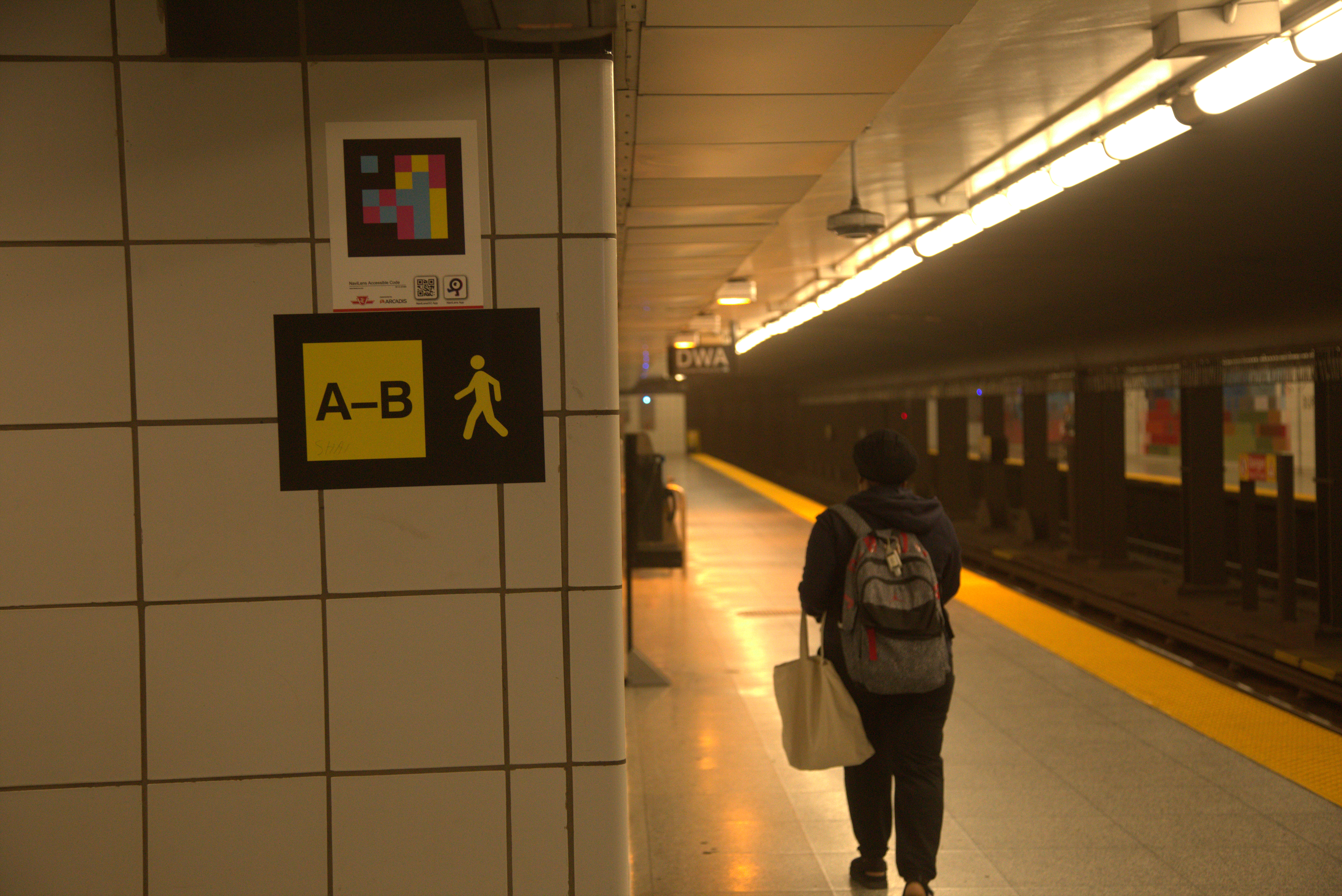
As part of the wayfinding pilot, the TTC has added NaviLens codes at entrances and key locations throughout Dufferin Station. These high-contrast codes provide audio guidance, directions, and contextual information in multiple languages using compatible mobile tools and apps. NaviLens codes can be scanned from up to 12 metres away using a smartphone camera and are designed to work even when the camera is out of focus.
Frequently asked questions
-
Why is the TTC piloting a new wayfinding system?
The TTC is piloting station exit identification to make it easier for customers to navigate complex stations, especially during the busy summer months. Clear, consistent exit codes can reduce confusion, support smoother transfers and help manage congestion in high-traffic areas.
-
What is station exit identification?
Station exit identification assigns a unique letter or letter-number code (e.g., A or A1) to each exit. These identifiers appear on signs and can be used to match the exit you need to take to your street-level destination.
-
What are exit codes?
Exit codes are simple letters and numbers on signs in the station, like A or A1. They help you find the right exit more easily.
-
What do exit codes like A1 or B2 mean?
Each station exit is given a simple code.
- The letter shows the exit area or zone (for example, A or B)
- The number shows a specific exit in that area (for example, A1 or B2)
The codes make it easier to follow directions and confirm you’re heading to the right exit, especially in stations with multiple street-level exits.
-
Which stations are the signs in?
The signs are at Bathurst, Dufferin, Bloor–Yonge, Union, St Andrew and King stations.
-
What will customers see in the stations?
Customers will see new yellow directional signs in key areas of the station, such as platforms, hallways, transfer points, and exits.
Customers will also see updated signs that show nearby streets, landmarks, and connections alongside the corresponding exit code.
-
Is this replacing existing wayfinding signage?
This pilot is designed to add clearer exit identification and improve navigation. Customers can continue using existing station landmarks and directions, while also using the new exit codes to confirm the best route out of the station.
-
How does the new wayfinding signage support accessibility?
The system is designed to reduce confusion and support customers who may experience visual, cognitive or language barriers by providing simpler, more consistent labels and clearer decision points throughout stations.
-
Where is NaviLens installed at Dufferin Station?
NaviLens codes are installed throughout Dufferin Station at the entrances, fare lines, platforms and key decision points to support independent navigation through the station.
-
Why is NaviLens only installed at Dufferin Station?
Dufferin Station was chosen because it is busy and has multiple exits and bus connections, making it a good station to test this technology.
-
Do I need an app to use the exit codes?
No, an app is not needed to use the exit codes. The exit codes are a simple navigation tool designed to be used on their own. In the future, digital tools and third-party apps may also use these identifiers as TTC public data is updated.
-
How long is the pilot, and what happens next?
The pilot will run from June to September 2026. During this period, the TTC will gather feedback and evaluate how well the new system improves navigation and customer experience to determine the next steps.
-
How can I share feedback about this pilot?
Customers can share feedback by contacting TTC Customer Service. If possible, please include the station name, the exit code (e.g., A1), the date and time, and a brief description of the issue or suggestion. A survey will also be available this summer for customers to share feedback on the pilot.